The following blog was written by Robert McIntosh, Community Success Manager, Telraam
Following the Local Elections on the 7th May, thousands of new and returning councillors will take their seats across the country. Their mandates will include developing updated Local Transport Plans (LTPs), setting ambitious targets for road safety and greener transport, and ultimately, helping to create vibrant and sustainable communities. Councils’ success will depend not only on policy design, but also on their ability to engage with the public, transforming traditionally contentious and complex decisions into collaborative community improvements.
Polling from YouGov shows that the most popular response to “the most important issue facing their local area” was the state of the roads, answered by over a third (37%) of respondents ahead of local elections. However, these decisions have historically been grounded in suboptimal data: manual traffic counts, one-off traffic surveys, expensive automatic traffic counters permanently embedded in the road surface, and temporary rubber tubes that stretch across roads, counting puffs of air when a vehicle wheel hits the tube. These methods work for counting cars, but are poor for classifying pedestrians, cyclists, or distinguishing between different types of heavy vehicles.
As a result, some crucial decisions have only been made within the narrow context of motorised vehicle data, skewing urban planning and local transport governance towards motor vehicles. When councils rely on top-down data that tells only half the story, measures to reduce traffic or improve pedestrian safety are not being assessed with sufficient continuous data to show their efficacy or otherwise. Without this data, arguments will continue to be based on subjective views rather than quantifiable outcomes. If the new guard of local leaders wants to solve speeding issues, reduce road danger, and encourage active travel, they must shift from snapshot data collection to continuous, street-level insights.
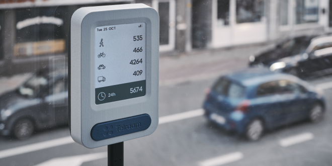
Telraam, Dutch for “counting window”, provides councils with a modern alternative fit for the world envisioned by the Department for Transport’s Transport Artificial Intelligence Action Plan, aptly subtitled “Transforming Ambitions”. Used already by a range of groups, from Manchester City Council to implement School Streets and European academics researching air pollution, to residents in Kibworth Village, Telraam is a camera sensor installed in buildings overlooking streets. It identifies objects using a specially trained AI, then categorises them, alongside direction of travel and vehicle speed. The device is affordable at less than £200 and easy to use, purposefully utilising low-resolution imagery to maintain privacy. Telraam builds a detailed map of speed patterns and road usage over time, not just over a random Wednesday in September.

Most importantly, it also tracks pedestrians, cyclists, and non-motor vehicles, distinguishing each. This can be used in the implementation of School Streets, as in Manchester, because Telraam not only monitors traffic patterns, but also observes modal shifts. Telraam can also provide a richer understanding of road safety, in which measuring travel speed is just as important as traffic volume. The device can show “open roads” that encourage speeding, indicated by high vehicle speeds and fewer cyclists and pedestrians, rather than traffic volume alone, which may be low.
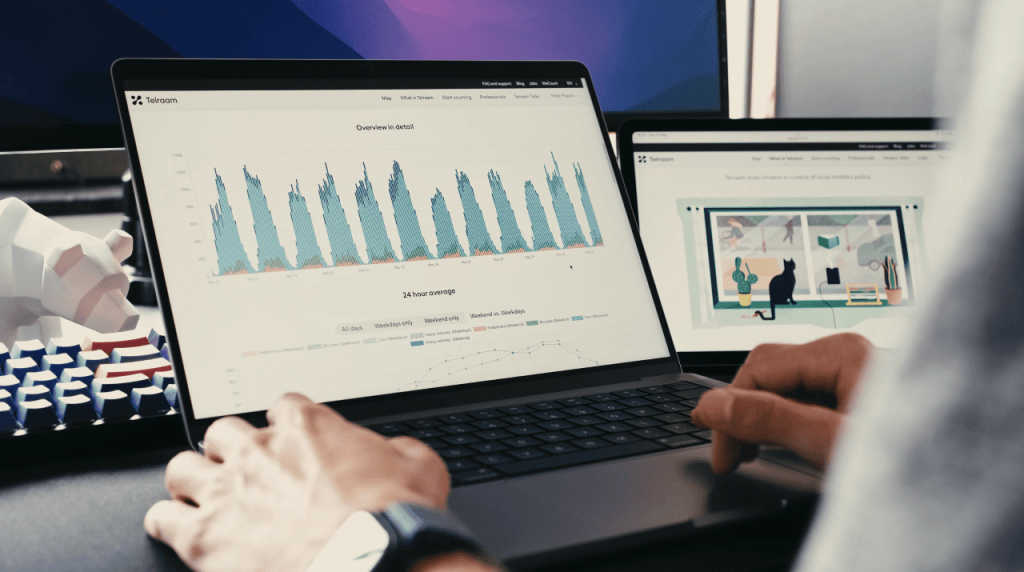
Beyond providing councils with good data, Telraam’s anonymised data is accessible, collectively gathered, and publicly available on Telraam’s map. “Local networks” of 10 to 300+ devices can recruit volunteers from the local Cycling and Walking Campaign Group, resident associations, and individuals frustrated with speeding in their neighbourhood, thus bridging the gap between the council and the communities. When citizens have access to the same high-quality data as the council, transport planning becomes a collaboration rather than a conflict. Technology like Telraam depoliticises traffic measures by grounding them in undeniable, shared facts.

Oxford City, with at least 20 Telraam counters and 4 more in Oxfordshire, provides a roadmap to citizen-backed transport governance. Emily Kerr, Green Party Councillor for St Mary’s Ward, uses the devices to see how many cyclists and pedestrians use LTNs, with 2,000 to 3,000 per day in the area between Cowley and Iffley Roads. Residents of Jeune Street use Telraam to report how many cars drive down the wrong way. The device captured heavy pedestrian use of Bullingdon Road and, as a result, Oxford City Council will request it be gritted before other streets in winter. Residents can request enforcement for the now-evidenced speeding on Headley Way. Kerr highlights the breadth of applications for AI traffic monitoring, from establishing cause and ensuring policy decisions are grounded in representative data to monitoring the effects of traffic interventions.
Decisions at the ballot box on Thursday will define the next four years for hundreds of thousands of people across the country. Councillors will inevitably face a variety of problems, and fixing them can take time. Low-cost technology such as Telraam can be deployed in a very short time frame, ensuring that not only is there better data for the long-term, but action is being seen to be taken straight away.
For more information on Telraam, please visit:

