Google has introduced advanced bike-sharing information into its Maps navigational platform.
The new feature, which includes live bike and docking availability, has rolled out in ten cities throughout the world: Chicago, London, Mexico City, Montreal, New York, Rio De Janiero, San Franciso, Sao Paulo, Taipei and Washington. It will roll out in further locations in the months to come.
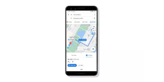
The update also brings ‘detailed walking directions to the nearest bike-share station, turn-by-turn cycling directions to the bike-share station closest to a user’s destination, and last-mile walking directions to a user’s final destination’.
For some cities, Maps will show you links to open the relevant bike-share app to book and unlock the bike.
“To give you the most up-to-date bike route, we use a combination of machine learning, complex algorithms, and our understanding of real-world conditions based on imagery and data from government authorities and community contributions,” said Google in a blog post. “We also consider various forms of bike lanes and nearby streets that might be less friendly for your two wheels so you can have the best and smoothest biking route.”